Appearance
Upload Tool
Overview
The Upload Tool is a versatile data import utility that seamlessly integrates external spatial data into your Horizon maps. Located in the right panel, this powerful tool supports multiple geospatial formats and automatically processes, validates, and integrates uploaded data into your current map view with intelligent coordinate system handling and automatic area calculations.
Upload Dialog
The Upload Tool opens in a draggable, resizable dialog. The dialog heading updates dynamically to show "Upload File to Map" during file selection and "Upload Complete - {filename}" after successful processing.
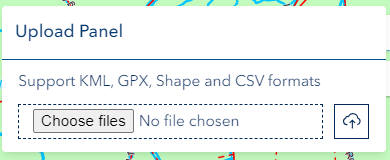
The dialog includes:
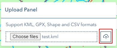
- Drag-and-Drop Zone: Drop files directly onto the dialog or click to browse
- File Preview: Shows the selected file name, type, and size with a remove button before uploading
- Projection Selection: For Shapefiles, a dropdown appears to select the coordinate system (auto-detected from .prj files in ZIP archives)
- Processing Status: Displays a loading indicator and progress feedback during upload and processing
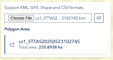
- Success Notice: Shows calculated polygon area (in hectares) after successful upload
- Footer Buttons: Cancel / Close (left) and Upload to Map (right)
The dialog is non-modal, allowing you to continue interacting with the map while the upload dialog is open.
Supported Files
File Types
| Format | Extensions | Description |
|---|---|---|
| Shapefile (ZIP) | .zip | ZIP archive containing shapefile components (.shp, .dbf, .prj, .shx). Recommended — supports automatic projection detection from the .prj file. |
| Shapefile | .shp | Standalone Esri Shapefile. Requires manual projection selection since no .prj file is included. |
| KML | .kml | Keyhole Markup Language — Google Earth format for spatial data. |
| GPX | .gpx | GPS Exchange Format — standard format for GPS routes, tracks, and waypoints. |
| CSV | .csv | Comma-Separated Values with latitude/longitude coordinate columns in WGS 84. |
Format Requirements
- ZIP Shapefiles: Must contain at least a
.shpfile. The.dbf(attributes),.prj(projection), and.shx(index) files are optional but recommended. If a.prjfile is included, the coordinate system is auto-detected. - Standalone Shapefiles (
.shp): You must manually select the coordinate system from the projection dropdown. Defaults to GDA94 / MGA Zone 55 (EPSG:28355). - CSV files: Must include latitude and longitude columns in WGS 84 (EPSG:4326).
- KML / GPX files: Standard format — no additional requirements.
- Maximum file size: 100 MB per file.
Using the Tool
Accessing Upload Panel
- Locate upload icon in right panel
- Click to open Upload panel

File Selection
- Click to browse your local system, or drag and drop a file directly onto the dialog
- A file preview appears showing the file name, type, and size — use the remove button to clear and select a different file
Projection Selection (Shapefiles)
When uploading a ZIP shapefile that includes a .prj file, the coordinate system is automatically detected and displayed in the projection dropdown. A success notification confirms the detected projection.
When uploading a standalone .shp file or a ZIP without a .prj file, you must manually select the source coordinate system from the dropdown. The following projections are supported:
| Projection | EPSG | Description |
|---|---|---|
| GDA94 / MGA Zone 55 | 28355 | Tasmania, Victoria (Default) |
| GDA94 / MGA Zone 54 | 28354 | South Australia, Western Victoria |
| GDA94 / MGA Zone 56 | 28356 | NSW, ACT, Eastern Victoria |
| GDA2020 / MGA Zone 55 | 7855 | Tasmania, Victoria (Modern) |
| GDA2020 / MGA Zone 54 | 7854 | South Australia (Modern) |
| GDA2020 / MGA Zone 56 | 7856 | NSW, ACT (Modern) |
| WGS 84 | 4326 | Global Geographic (Lat/Long) |
| GDA94 | 4283 | Australia Geographic |
| GDA2020 | 7844 | Australia Geographic (Modern) |
| Web Mercator | 3857 | Google/Bing Maps compatible |
All uploaded geometries are reprojected to WGS 84 for display on the map.
Upload Process
Click Upload to Map to begin processing. The tool progresses through the following stages:
- Reading — file content is read from disk
- Parsing — format-specific parsing (shapefile geometry, XML for KML/GPX, CSV columns)
- Creating — feature layer is created and added to the map
- Complete — the map automatically zooms to the uploaded features
A loading indicator and status message are displayed throughout each stage.
Area Calculation
For polygon uploads, the total area is automatically calculated and displayed in hectares (ha) in the success notice after upload completes.
Technical Notes
File Limits
- Maximum file size: 100 MB per file
- Maximum decompressed ZIP size: 500 MB (to prevent processing issues with oversized archives)
- Allowed extensions:
.shp,.csv,.kml,.gpx,.zip
CSV Behaviour
- Must contain latitude and longitude columns in WGS 84
- Points are displayed with feature clustering — nearby points are grouped and show a count label
- Clicking a cluster zooms in to reveal individual points
Shapefile Specifications
- ZIP upload (recommended): Bundle
.shp,.dbf,.prj, and.shxfiles into a single ZIP archive. Only the.shpfile is required; other components are optional. - Projection detection: If a
.prjfile is included in the ZIP, the coordinate system is auto-detected. Otherwise, select the projection manually from the dropdown. - All standard attribute fields from the
.dbffile are preserved and available in popups. - Uploaded features are separated by geometry type — a single shapefile may produce separate point, polyline, and polygon layers.
KML / GPX Notes
- Parsed using standard XML processing
- Original feature properties are preserved as layer attributes
- Geometry collections are supported
Troubleshooting
| Issue | Solution |
|---|---|
| "Invalid file type" | Only .shp, .csv, .kml, .gpx, and .zip files are accepted. Ensure the file has a correct extension. |
| "File too large" | Files must be under 100 MB. Reduce the file size or split into smaller files. |
| ZIP upload fails | Ensure the ZIP contains at least a .shp file. The archive must not exceed 500 MB when decompressed. |
| Shapefile displays in wrong location | The wrong projection was selected. Re-upload with the correct coordinate system, or use a ZIP with a .prj file for auto-detection. |
| CSV points not displaying | Confirm the file has latitude and longitude columns with values in WGS 84 decimal degrees. |
| No area shown after upload | Area calculation only applies to polygon geometries. Point and line uploads do not show an area. |
| Layer not visible on map | Check the layer visibility toggle in the Layer Panel. The uploaded layer may be behind other layers. |
Video Tutorial
Watch this guide on using the Upload Tool: